Floodplain Mapping of the Chilliwack River, BC
– Vedder Crossing to Slesse Creek
Yihang (Eric) Shi, MLWS 2016
Floodplain mapping is critical for the Federal and BC governments to develop policies and strategies to prepare for potential flooding events. BC communities that lack up-to-date floodplain maps risk billions of dollars in property damage and their citizens’ lives. This study focused on the community of Chilliwack, BC and the Chilliwack River, which has historically been subject to recurrent and severe flooding.
Temperature and precipitation extremes have grown in recent years, leading to an increase in flood risks in the watershed. The floodplain map is nearly 30 years old. Water levels typically rise during the spring and summer due to snowmelt. However, historic larger floods have occurred in the fall and winter, brought on by heavy rainfall or rain-on-snow events.
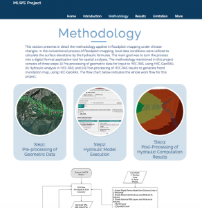
Current climate data expects that the modelled flood risk areas have changed since the last mapping period. This project aimed to update the map of this region by using hydraulic analysis (HEC-RAS) and GIS applications (HEC-GeoRAS, ArcMap). This project provides useful information for landowners, governments and local communities for the development of flood hazard strategies.