Water Resources Science/ Management
The following Major Projects investigate Water Resources Science/ Management issues.
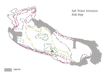
A Study of Water Balance in Gabriola Island, BC, Canada
Ke Hu, MLWS 2019
Gabriola Island, the most northerly of the Southern Gulf Islands, suffers from the lack of surface freshwater during summertime. Because the majority of water consumed on Gabriola Island is extracted from the groundwater system, only a small portion of consumed water is harvested rainwater. On Gabriola Island, groundwater in the fractured rock aquifers is recharged from rainwater. Over-pumping from fragile groundwater resources to meet increasing water needs leads to saltwater intrusion into the potable water supply sources, caused by the rapid increase of population during summertime.
The purpose of this project is to provide an assessment the water balance of Gabriola Island, as it is being affected by land-use changes, increase seasonal tourist populations and increased climatic variability. The aim of the paper is to conduct a risk assessment of saltwater intrusion resulting from future climate change scenarios.
Groundwater Predictive Model on the Effect of Land Use Impacts on the Hopington Aquifer in Langley, BC
Juncheng Hu, MLWS 2019
The Hopington AB Aquifer is one of the most vulnerable unconfined aquifers in the lower mainland. It is reported that the Hopington AB aquifer water level is decreasing year by year. The predictive model indicates that these declines are due to excessive extraction, climate change and expected population growth will only accelerate the drop in water tables. In order to address the groundwater quantity issue, a groundwater management plan is needed to regulate and protect the unconfined aquifer.
The overall goal of the project is to determine the water balance of the Hopington Aquifer and its possible impact on streamflow in the Salmon River. The aim is to develop a predictive model to determine the effect of land use activities and water use on the Hopington Aquifer, to show if the aquifer is used in a sustainable manner and to evaluate if changes affect the stream water flow in the Salmon River.
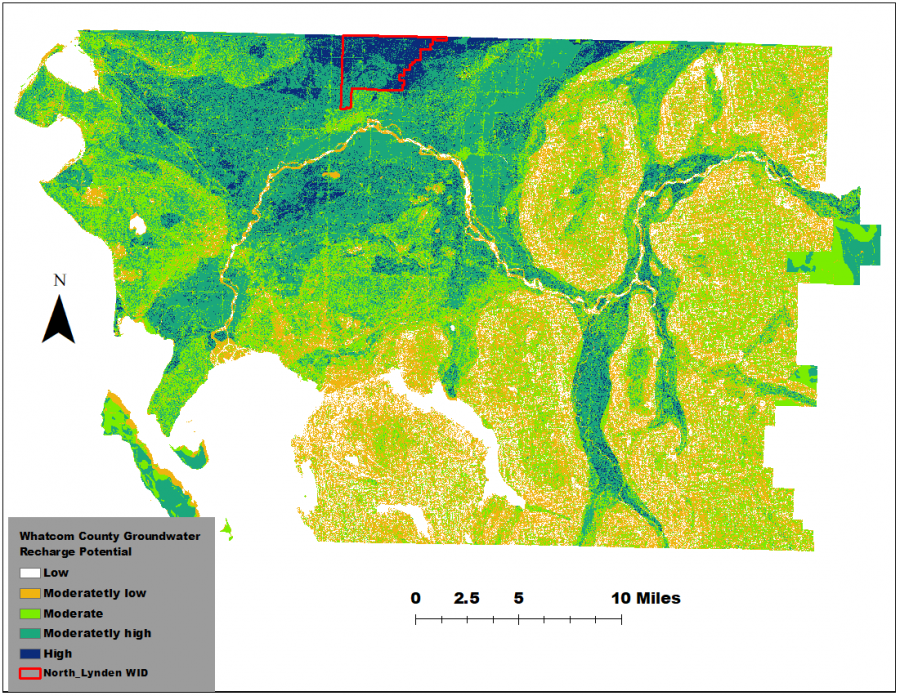
GIS Assessment of Groundwater Recharge Potential in Whatcom County, Washington State:
Implications for Land Use
Olatunbosun Ayetan, MLWS 2019
Ecosystem services such as groundwater recharge play an important role in sustainable management of groundwater resources. The present study was carried out to identify and map zones in the North Lynden Watershed Improvement District (NLWID) that have productive groundwater recharge potential using Geographical Information System (GIS). The NLWID is part of the Fishtrap Creek Watershed, which is faced with land use changes, loss of resource land and farmlands that have the potential to reduce natural recharge of the Sumas-Abbotsford Aquifer. A penetrometer field test was carried out to investigate soil compaction and the relationship between land cover and groundwater recharge potential. The penetrometer field test qualitatively revealed that land cover and the required management practices in addition to the soil types can affect groundwater recharge potential. The results of the study can be used to formulate an efficient groundwater recharge management plan for sustainable utilization of limited groundwater resources.
Microplastics: The Hidden Hazard
Xin Dong, MLWS 2018
This white paper provides a holistic overview of the microplastics problem, including the various components and sources of microplastics, their distribution and abundance, and the impacts of microplastics on the environment and human life. The goal of this paper is to make the public aware of the hidden hazard of microplastics, and thus take appropriate actions to mitigate the hazard. There are several removal solutions for microplastic contamination, including source control, recycling and advanced removal techniques for wastewater treatment, such as membrane bioreactors. The main solution for mitigation rests with public awareness and government legislation. To date, the research on microplastics has been concentrated on aquatic environment and organisms. The study of the impact of microplastics on human health is still in its infancy, and further long-term research of human effects is needed.

A Theoretical Stemflow Model for Urban Trees with an Evaluation of Current Street Tree Pit Design and Practices
Anne Day, MLWS 2018
Cities across the world are dealing with storm water runoff and its management, as urbanization leads to urban densification. The use of urban forestry has become widely accepted as a more resilient means to address storm water management problems in the face of densification and climate change. The project’s development of a theoretical stemflow model works to predict the volume of stemflow on an event basis for several common tree species that are used in the Metro Vancouver area as street trees. The model is based on a linear relationship between stemflow volume (L) and precipitation depth (mm) in relation to tree diameter at breast height (DBH) (cm). The model performed well and was able to reasonably predict stemflow volumes based on inputs of DBH and precipitation. Based on two modeling approaches, it was found that modeling stemflow based on grouping all trees together is more accurate in comparison to modeling stemflow based on grouping the trees by genus.
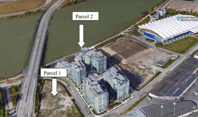
Urban Land Subsidence:
A Case Study in Richmond, British Columbia
Tishtaar Titina, MLWS 2018
Groundwater extraction can cause soil to consolidate and land to subside. Land subsidence increases relative sea-level rise and exacerbates inundation hazards for coastal cities. The City of Richmond is a low lying floodplain, on average 1 m above mean sea level, with increasing development due to urbanization. This makes it imperative that Richmond maintains its high water table to prevent subsidence. Furthermore, Richmond’s high water table necessitates dewatering at excavation sites in order to proceed with construction processes. Examining the impacts of dewatering based subsidence in Richmond, on a neighbourhood scale, highlights why groundwater levels should be maintained on a city-wide scale. Richmond can evaluate management practices utilized globally that contribute to the maintenance of the groundwater table to further mitigate subsidence and to combat potential effects of climate change.
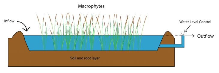
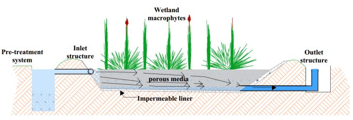
A Case Study of Constructed Wetlands Application to Restore Habitats and Treat Wastewater
Li Wang, MLWS 2018
Constructed Wetlands (CWs) have been seen as a practical and cost-effective solution to solve both wastewater issues and habitat loss issues. The use of constructed wetlands in Canada is, however, less common than in other countries. The main objective of this project is to investigate the current development of constructed wetlands and the current application of Constructed Wetlands in Canada. The elements of CWs, different types of CWs, as well as the advantages and limitations of CWs were reviewed in this report. In order to assess the current application of CWs in the west coastal area of Canada, a case study in the Greater Vancouver region was selected. It is expected that CWs provide multiple benefits to both wildlife and local communities. Further studies are required to understand the viability and long term performance of CWs in Canada.
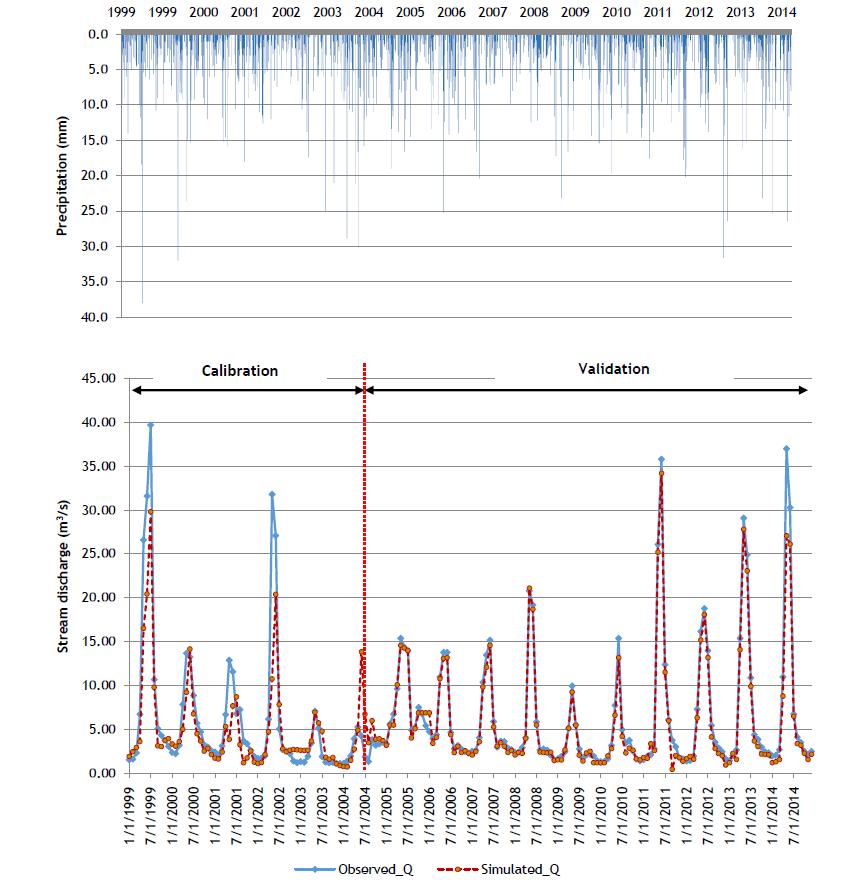
Using SWAT to Simulate the Effects of Forest Fires on Water Yield in Forested Watershed:
A Case Study of Bonaparte Watershed, Central Interior of British Columbia, Canada
Abia Katimbo, MLWS 2018
Climate change has impacted the forested watersheds of British Columbia by bringing extremely high temperatures and beetle infestations, thus coinciding with increasing amounts of forest fires. On average, it is estimated that about 10,000 fires occur every year in Canada, burning about 2 million ha of the 400 million ha forested landscape. One of the areas that was most affected by the forest fires in 2017 was the Cariboo Regional District in the central interior of British Columbia. Wildfire burns away the ground cover of the landscape, exposing soils to erosion under heavy storms. The major objective of this study was to simulate the changes in water yield in the forested watershed during pre- and post-wildfire periods, using Bonaparte watershed as the study area. The SWAT model was used for water yield simulations, in order to evaluate the hydrological response of the watersheds to forest fires.
Comparative Transboundary Nitrogen Budget of the Abbotsford–Sumas Aquifer
Kamal Kakish, MLWS 2018
Transboundary groundwater issues are of significant importance. The depletion of aquifers is adding pressure to growing water scarcity in many parts of the world; and groundwater quality is being reduced as a consequence of several sources of anthropogenic pollution, which eventually restricts its uses in certain applications.
Future sustainable management of shared resources requires a shift toward holistic cooperation, while strengthening the scientific knowledge available, to effectively inform policy actions. This is particularly important within the Abbotsford – Sumas Aquifer, a Transboundary Aquifer (TBA) system shared by British Columbia and Washington State, USA.
In this paper, a comparative nitrogen budget analysis is conducted on the Abbotsford-Sumas Aquifer and includes all major agricultural nitrogen flows. The study compares nitrogen surplus amounts on both sides of the border. This provides an indicator of excess nitrogen that could be leaked into the environment and eventually contribute to the contamination of the aquifer. Furthermore, conceptualizing nitrogen flows at the regional scale within the extent of the aquifer could promote a more effectual design of intervention measures and conjunctive policy creation for the sustainable management of the transboundary Abbotsford-Sumas Aquifer.
Exploratory Assessment of Drinking Water Management in the Southern Interior of British Columbia:
A First Nation Story
Destiny Allen-Green, MLWS 2018
By way of a reconnaissance, this report presents an evaluation of some of the challenges pertaining to drinking water access and availability in the Lytton First Nation and Esh kn-am.
The Lytton First Nation had recently installed a new water treatment system. The communities represented by Esh-kn-am had challenges with water shortages and some sporadic Boil Water Advisories (BWAs). The current water management does not provide long-term solutions, and as such, potable water will always need to be treated if further actions are not taken.
As a result, a holistic approach to drinking water management has been recommended for both community groups. The use of watershed-level management by way of the multi-barrier approach and/or integrated watershed management more effectively protects water at its source and better ensures the quality of the water at the tap. Additionally, these holistic methods generate more collaboration and require that adequate data be gathered, both of which are needed in addressing drinking water concerns. Despite watershed level management of drinking water sources being a viable solution, the communities have little control over local governance, especially within their traditional territory, which hinders the more holistic approaches.
Constructed Wetlands: A Potential Alternative Technology for the Treatment of Wastewaters From Institutions in Rwanda
Charles Mungwakuzwe, MLWS 2017
In Rwanda, it is nearly impossible to collect domestic wastewater with centralized systems, due to the lack of financial investments and the sanitation chains. However, on-site systems such as constructed wetlands may be feasible for wastewater treatment in schools and other similar sized institutions. Constructed wetlands are an alternative technology to conventional wastewater treatment to explore due to their operational simplicity and requirements. This project provides technical information and review of two constructed wetland designs (surface flow and subsurface flow constructed wetlands) and proposes a horizontal subsurface flow constructed wetland for Indatwa n’Inkesha school. The treated effluent will meet the regulatory targets of Rwanda Utilities Regulatory Authority for domestic wastewater discharge and could be reused in agriculture. It is expected that the adoption of constructed wetland technologies in Rwanda will depend on the land availability, sanitation chains and safety factors. Further studies are required to understand the viability of this technology, and to provide monitoring data about their long-term performance.
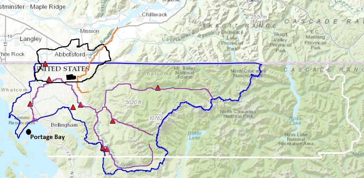
Preliminary Assessment of Flooding Hazards in the Nooksack River Watershed, Washington State, and its Effect on Water Quality and the Local Shellfish Industry
John Prizzi, MLWS 2017
Flooding in the Nooksack River in northwestern Washington State has been the product of heavy rains occurring between the months of October and March (Nooksack Indian Tribe, 2016). Increasing winter temperatures will decrease the amount of snowfall experienced along the Nooksack River floodplain and Whatcom County and replace it with rainfall. Heavy rainfall and overland flow along the floodplain has the potential to move sediment, organics, and contaminants from the floodplain to the Nooksack River (NOAA, 2015).
To investigate influences on fecal coliforms concentrations in the Nooksack River, the relationship between flood events and fecal coliforms concentrations was analyzed. Conclusions drawn from this relationship then analyzed how increasing temperatures and precipitation would affect the frequency of floods over the next 50 years, and the potential response of the fecal coliform concentrations in Portage Bay. It is expected that flood frequency will increase over the next 50 years. As a result, fecal coliform concentrations in the Nooksack River and Portage Bay will increase.
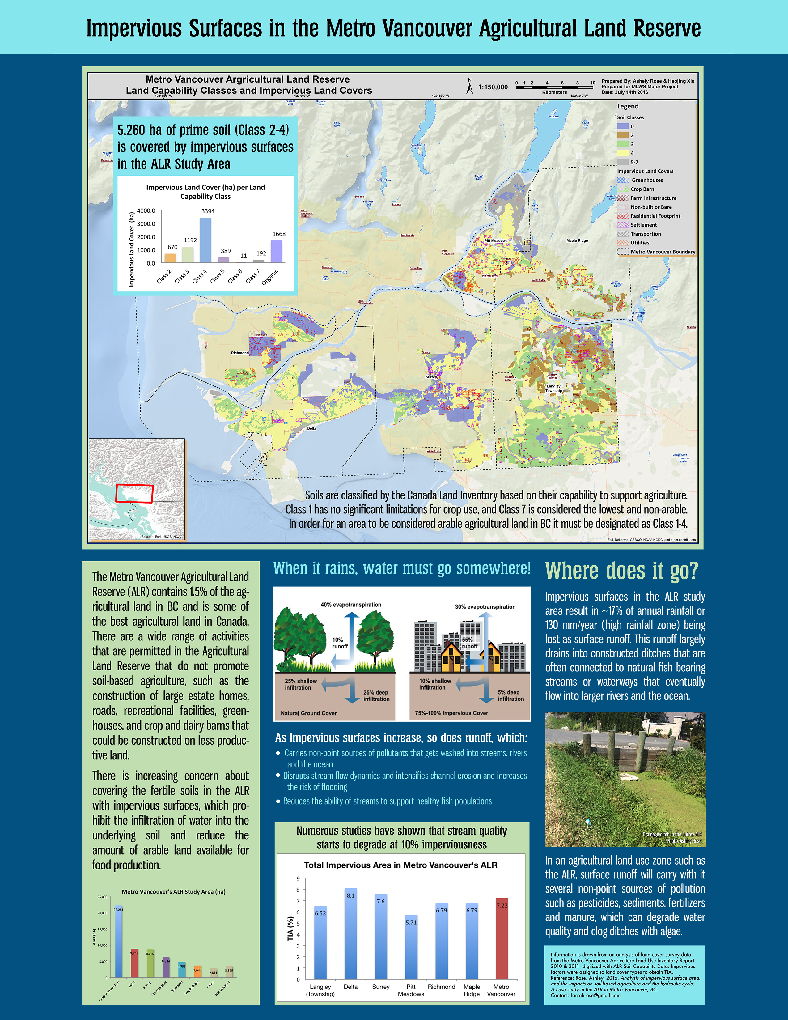
Analysis of Impervious Surface Area, and the Impacts on Soil-Based Agriculture and the Hydrological Cycle:
A Case Study in the Agricultural Land Reserve in Metro Vancouver, BC, Canada
Ashley Rose, MLWS 2016
The Agricultural Land Reserve (ALR) was originally established with the goal of protecting prime agricultural soils from being lost to urbanization and other development in the province of British Columbia. However, there are a wide array of activities that are permitted in the ALR such as the construction of greenhouses, crop and dairy barns, estate-sized homes, roads, and commercial facilities that permanently seal the soil with impervious surfaces and take the soil out of production.
The objective of this study was to estimate the extent of impervious surface area in the Metro Vancouver ALR in order to analyze the impacts on the hydrologic cycle and to quantify the amount of arable agricultural land that is taken out of production, based on the Soil Capability for Agriculture classification. The information in this report is useful in developing watershed protection strategies and assisting policy makers in making land use decisions to protect the long term integrity of the ALR and soil-based agriculture.
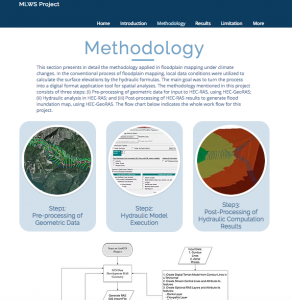
Floodplain Mapping of the Chilliwack River, BC
– Vedder Crossing to Slesse Creek
Yihang (Eric) Shi, MLWS 2016
Floodplain mapping is critical for the Federal and BC governments to develop policies and strategies to prepare for potential flooding events. BC communities that lack up-to-date floodplain maps risk billions of dollars in property damage and their citizens’ lives. This study focused on the community of Chilliwack, BC and the Chilliwack River, which has historically been subject to recurrent and severe flooding.
Temperature and precipitation extremes have grown in recent years, leading to an increase in flood risks in the watershed. The floodplain map is nearly 30 years old. Water levels typically rise during the spring and summer due to snowmelt. However, historic larger floods have occurred in the fall and winter, brought on by heavy rainfall or rain-on-snow events.
Current climate data expects that the modelled flood risk areas have changed since the last mapping period. This project aimed to update the map of this region by using hydraulic analysis (HEC-RAS) and GIS applications (HEC-GeoRAS, ArcMap). This project provides useful information for landowners, governments and local communities for the development of flood hazard strategies.
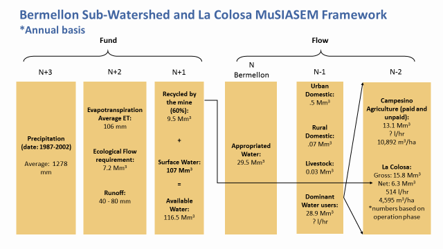
Assessing Water Appropriation and Equity in the Coello and Bermellon Watersheds, Colombia
Roya Bennett, MLWS 2016
The Multi-Scale Integrated Analysis of Societal and Ecosystem Metabolism (MuSIASEM) approach assesses the complex interactions between socioeconomic and environmental facets of water resources. MuSIASEM presents a systematic project planning and implementation strategy for project facilitators, and was applied in a case study region, the Coello and Bermellon watersheds in Colombia. These watersheds are under examination by local NGOs (Comité Ambiental en Defensa de la Vida (Environmental Committee in Defense of Life)), the regional environmental authority (Cortolima), and the downstream irrigation district (UsoCoello), as plans move forward to build an open-pit gold mine, La Colosa.
This analysis raised concerns about the potential of over-appropriation of water in the dry season, and identified potential conflicting uses between the proposed mine and the agricultural sector. Currently, water is being appropriated at quantities approaching the average annual water availability and discharges do not meet the demand of downstream uses during parts of the year. Livelihoods in the region are dependent on water associated with agricultural activities, thus concerns of equitable water availability and appropriation need to be addressed before any decisions or policies regarding future industries are implemented.
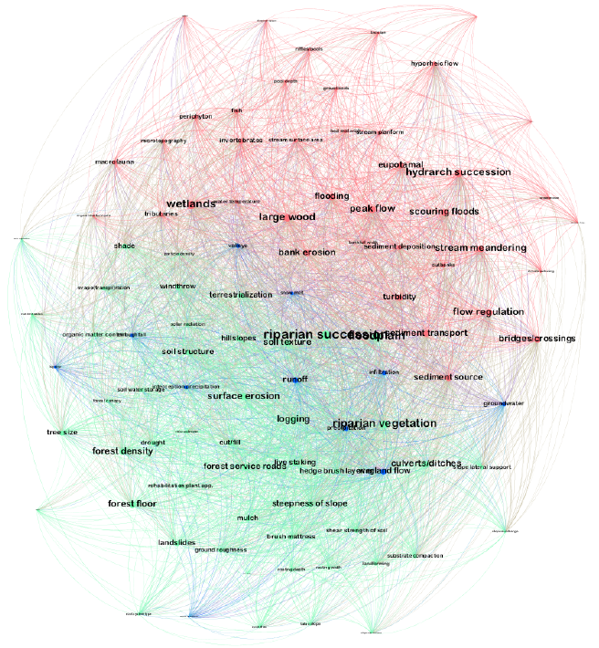
Conceptualizing Stream Ecosystem Restoration
P. Clemens Langemeyer, MLWS 2016
Land managers and conservationists generally agree that ecocentric restoration is a mandatory practice with regard to the development of a sustainable future. Present-day restoration projects continue to be undermined by conceptual models founded decades ago: river systems were seen as inherently homogenous, held in equilibrium by natural processes, and that these processes remained constant regardless of scale. This has led to the continued misunderstanding of the heterogeneity and interconnectivity of streams, a perception that is still represented by conventional restoration practices.
The Stream Ecosystem Network is an interactive digital mind map that stimulates thought with respect to ecosystem connectivity, allowing users to visualize various components of stream ecosystems, and how they are interrelated. Environmental professionals capable of identifying and communicating interactions between system components across a multitude of disciplines (systems-thinkers) are a valuable asset to the continued development of this network. This project reviews and discusses how the network might benefit restoration ecologists throughout project development. Several published guidelines serve as a platform for discussing restoration strategy development and the re-integration of riverine natural processes.
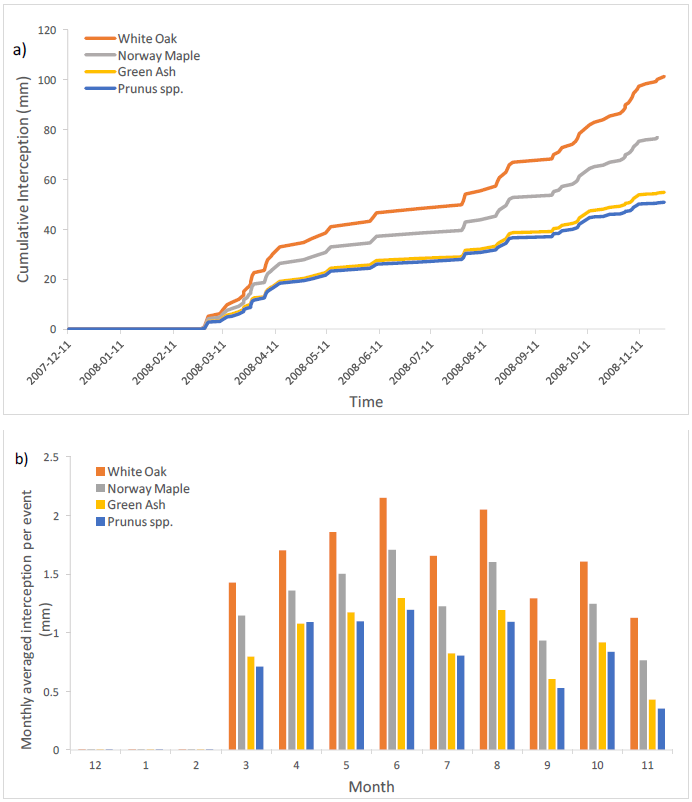
An Analytical Model of Rainfall Interception by Urban Trees
Jie Ying (Jenny) Huang, MLWS 2016
Urban trees are recognized for their capacity in improving air quality, aesthetic values and reducing energy consumption, while their ability to help divert rainfall and reduce urban runoff are often overlooked. This study provides an analytical model on rainwater interception performance of a selection of common urban trees in Metro Vancouver, given a series of climatic and tree characteristics. The model outputs and interface are designed to inform and enhance decision support tools that are used in the development of stormwater management plans and permit applications associated with urban development projects.
A specific goal of this study includes: developing a rainfall interception model with different approaches to deriving model parameters. The rainfall interception model provides useful information to address several aspects of urban stormwater management for different stakeholders. The potential audiences who will benefit from the outcomes of this study are people involved in urban planning and management of stormwater such as city/municipal planners, engineers, developers, and local decision makers.
View full report in the Canadian Water Resources Journal (PDF)
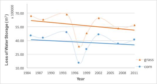
Effects of Aggregate Extraction on Water Storage in the Pepin Creek Watershed, British Columbia, Canada
Yining (Rachel) Wang, MLWS 2016
View article in Scientific Researcher – An Academic Publisher
Rain Water Harvesting with the Homegrown Rainwater Model
Encouraging Alternative Water Resources for Small Scale and Urban Agriculture
Acadia Tucker, MLWS 2015
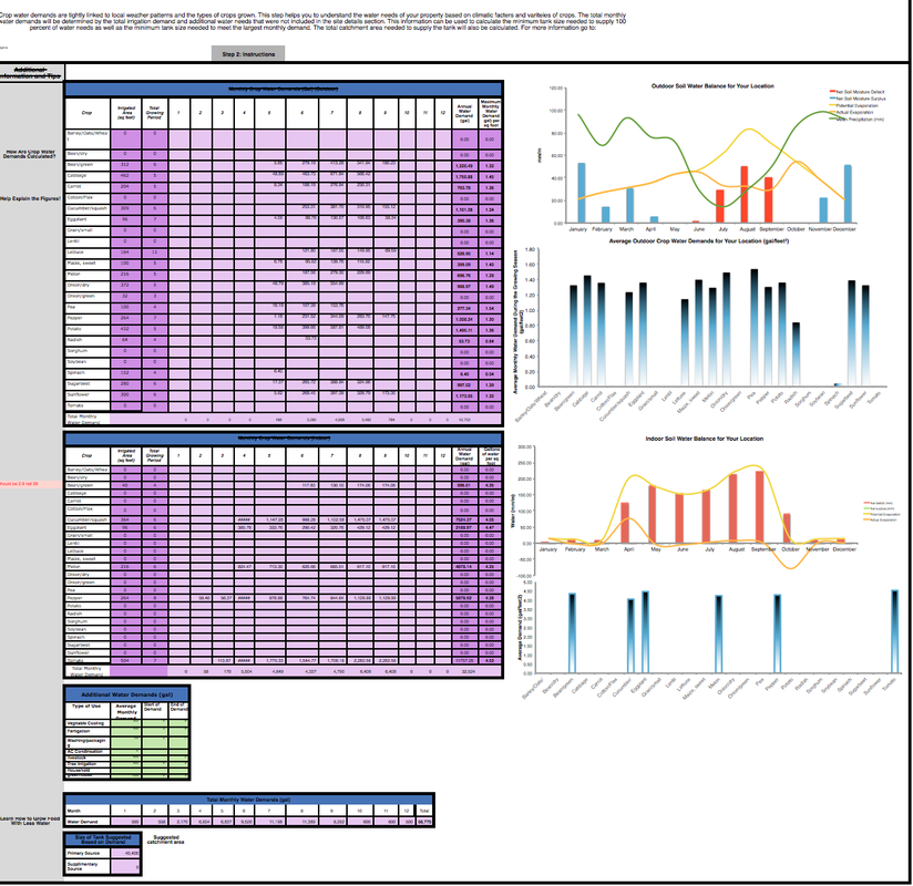
Alternative water resources, like rainwater harvesting, are under-utilized yet offer a decentralized approach that can increase the reliability and resiliency of urban water supplies, particularly for urban agricultural production. By exploring alternative approaches to water use and distribution, urban areas can decrease their dependency on large scale water systems and avoid the risks associated with centralized water supplies. Now is the time to start planning for a more unpredictable future in a way that mitigates the adversity linked with these events. The Homegrown Rainwater Model was designed and developed to help small scale growers determine the feasibility of installing a rainwater system at a site. The model design is based on three different steps to help users fully understand the potential system requirements that work best for each individual situation. The model predicts a specific location’s water supply and demand based on easily accessible information such as local precipitation, air temperature and irrigated area.
Run-of-River Hydroelectric Projects and Cumulative Impacts in British Columbia
Adam Ftaya, MLWS 2015
The expansion of run-of-river (ROR) hydroelectric operations in British Columbia since the early 1990s has raised concerns over the potential cumulative effects arising from multiple ROR sites and additional land-uses within a watershed. While this concern has been expressed by a multitude of interest groups, cumulative effects assessments (CEAs) are still a developing concept, and ROR-centric CEAs are often hard to find or lacking in detail. A central issue is the lack of research regarding the environmental impacts of ROR operations and their associated infrastructure. To address these challenges, this study focuses on identifying the key land-use and aquatic changes that have occurred in the Clowhom River watershed in southwestern BC, an area that has recently undergone ROR development. The potential impacts of each ROR project component were identified through a literature review; these impacts were then examined in a cumulative manner along with the potential impacts from additional watershed activities and climate change. Results suggest that the cumulative effects of ROR developments will be largely determined by the pre-ROR state of watershed development and infrastructure.
Connecting the Drops:
An Agricultural Water Assessment and Strategy for Surrey, BC
Michelle Radley, MLWS 2015
Conflict over resources is particularly problematic in peri-urban areas where urban and rural development relies on the same land and water resource systems. Peri-urban agriculture is a valuable form of agriculture that provides environmental, recreational, and food security benefits to urban areas. However, urban competition for land and water and a lack of system-based planning has led to the fragmentation of arable land, stressed water systems, and a consequent decline in the potential for peri-urban agricultural production.
This project uses the city of Surrey, British Columbia, Canada as a case study for developing a regional, system-based strategy for increasing peri-urban agricultural productivity. The strategy focuses on integrating the management of geographically-fixed soil resources with water resources that flow through time and space. A water chain analysis and a water resource suitability assessment reveal that opportunities, vulnerabilities, and inefficiencies exist within Surrey’s water system. These results are applied using a holistic decision-making framework in order to demonstrate how alternative water harvesting and cropping opportunities may be developed and inform the directions for policy.
Cumulative Ecological Impact of the Residential Construction Industry on Watershed Health in Three North Shore Communities in the Lower Mainland of BC
Erika Nassichuk, MLWS 2015
There are many issues associated with the impacts of residential construction on watersheds. Examples include: sediment-laden or chemically contaminated water entering into watercourses, and a trend towards larger building footprints that can reduce the amount of land available for rainwater infiltration. The cumulative effects of widespread construction are not well understood. There is not currently an easy-to-follow guide to help builders and contractors minimize damage to the surrounding watershed while building or renovating single-family homes. There are two overall objectives associated with this project. The first is to create a clear, easy to follow online educational resource that can inform developers of the potential negative impacts of residential construction on watercourses and watersheds. The second objective is to encourage the use of Beneficial Management Practices (BMPs) by the construction industry, in order to facilitate small changes to improve urban watershed health. A guiding framework was developed to aid both developers and homeowners to minimize their impact on watersheds by activities.
Water Availability and Climate Change
Chapman Creek Water System, Sunshine Coast, BC
Monte Staats, MLWS 2014
Chapman Creek is the main water source on the Sunshine Coast, BC, and services approximately 22,000 people. Concerns have been expressed that increasing water demand due to population growth and increasing climatic variability may lead to water shortages during the summer season and insufficient summer stream flows to maintain a healthy aquatic environment. A water demand and supply analysis was conducted for the Chapman water system to determine how climate change will impact water consumption and future water supply. The analysis reviews historic temperature, precipitation, discharge and water consumption data to determine historic trends. This study examines relationships between climate and water consumption to provide insight into the potential impacts from climate change on water supply and demand during the summer season.
